
Quick Summary
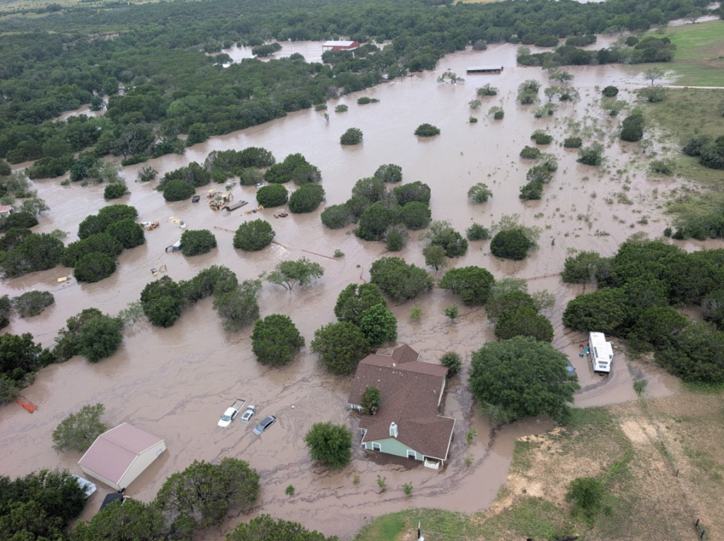
Catastrophic Texas flooding struck the Hill Country for the second summer in a row this week, as the Guadalupe River surged past last year’s record near Comfort and forced shelter in place orders in Kerrville, exactly one year after the July 2025 disaster that killed more than 130 people along the same river. At least two people have died, more than 230 have been rescued, and portions of 14 counties were placed under flash flood warnings after some areas received up to 8 inches of rain in just two hours. The Guadalupe rose from 5.46 feet to more than 37 feet in roughly three hours Thursday morning, a speed that stunned even veteran emergency managers, and the National Water Center warned that catastrophic flooding would remain a significant threat to life and property through Friday. For thousands of Hill Country residents still grieving last year’s losses, this week has been a terrifying case of history repeating itself, with one crucial difference: this time, the sirens worked.
What Happened
The National Weather Service office serving Austin and San Antonio issued a rare flash flood emergency at 3 a.m. Thursday for Hunt, Kerrville and Ingram, reporting that 3 to 6 inches of rain had already fallen with more coming down at rates of 2 to 4 inches per hour. What followed was one of the fastest river rises ever recorded in a region already infamous as “Flash Flood Alley.”
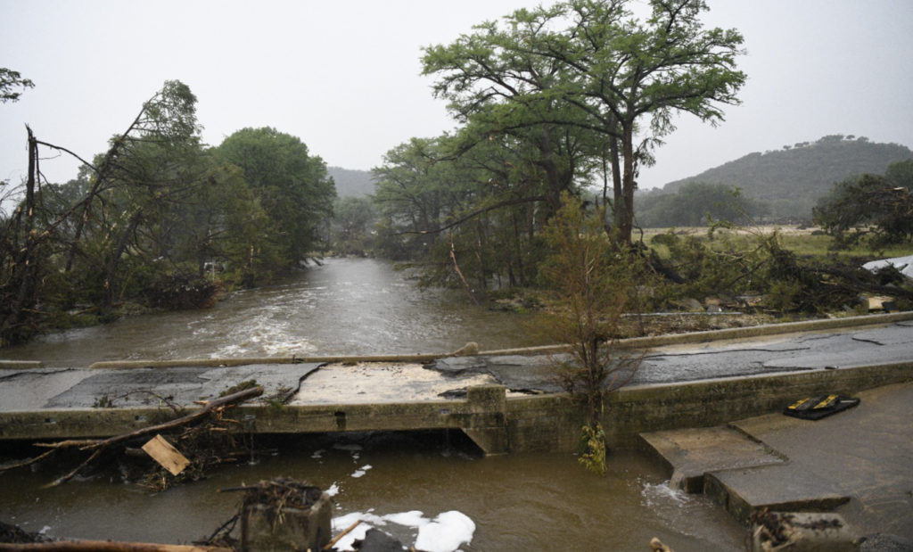
U.S. Geological Survey gauge data tells the story in brutal numbers. At Comfort, the Guadalupe River stood at 5.46 feet at 5 a.m. Central time. By 8:05 a.m. it had reached 37.05 feet, a rise of more than 31 feet in three hours, including a 16 foot jump in a single 30 minute window. That crest exceeded the record of 35.64 feet set during last year’s deadly Fourth of July floods by well over a foot. Downstream at Center Point, the river climbed 32 feet in four hours.
Flood sirens blared in Comfort early Thursday, part of a warning network expanded after the 2025 catastrophe exposed fatal gaps in the region’s alert systems. Kerrville residents were ordered to shelter in place as floodwaters cut off the Hunt area and closed Highway 39, while a major crash shut down a stretch of Interstate 10. Two people are confirmed dead: a 74 year old man in Uvalde County and a man of about 65 in Center Point, both apparently caught by the rising water.
Governor Greg Abbott said Thursday evening that more than 230 rescues had been carried out, with more than 2,350 responders and 1,400 vehicles deployed across the region. Helicopter crews from Travis County conducted air rescues in Kerr and Gillespie counties, and firefighters in Boerne pulled a woman from floodwaters on Wednesday as the first bands of rain arrived.
The Shadow of July 2025
It is impossible to understand this week’s fear without last summer’s grief. On July 4, 2025, the Guadalupe River rose with almost no warning in the pre-dawn darkness, sweeping through riverside camps and RV parks and killing more than 130 people, among them 27 campers and counselors at Camp Mystic, the century old girls’ summer camp near Hunt. The disaster became one of the deadliest inland flood events in modern American history and triggered months of investigations into why warnings failed to reach people sleeping along the river.
This week, the geography was chillingly similar but the outcome, so far, has not been. Floodwater near Camp Mystic reached roughly 20.5 feet, serious but far below last year’s record at that location, and the Kerr County Sheriff’s Office confirmed that all campers at the county’s summer camps were safe, with several camps keeping children indoors on higher ground. The sirens, upgraded river gauges and aggressive overnight warnings that emerged from last year’s failures appear to have done their job.
Preliminary rainfall measurements are staggering even by Hill Country standards: more than 19 inches in Kerrville and more than 21 inches in Uvalde over the course of the event, totals that approach what these towns would normally expect in half a year.
Why It Matters
Two catastrophic floods on the same river in two consecutive summers raise urgent questions that reach far beyond Texas. The Hill Country’s thin soil, steep limestone terrain and proximity to Gulf moisture have always made it America’s most flash flood prone region, but back to back record crests suggest the baseline itself is shifting. Warmer Gulf waters load storms with more moisture, and stalled summer weather patterns let that moisture fall on the same watersheds for hours. For homeowners, the practical consequences are immediate: flood insurance costs along the Guadalupe corridor were already climbing after 2025, and a second record flood will intensify pressure on both the private market and the National Flood Insurance Program.
The week is also an early test of whether post-2025 reforms worked. Texas lawmakers approved new funding for warning sirens, gauge networks and emergency communications after last year’s failures. A death toll of two, against more than 130 a year ago in comparable conditions, is a grim but real measure of progress, though officials caution the emergency is not over.
Impact Assessment
Politically, Governor Abbott moves quickly onto familiar disaster footing, and a federal disaster declaration request is likely within days, putting the White House’s disaster response posture back in the spotlight. Economically, the flooding hits a summer tourism corridor at peak season: river outfitters, camps and small town main streets in Kerrville, Comfort and Center Point depend heavily on July revenue. On the legal front, last year’s floods produced lawsuits over warning failures and camp safety, and this week’s near miss at the camps will be studied closely by both plaintiffs and defense teams as evidence of what adequate warning looks like. Public sentiment in the region is raw; residents interviewed by Texas outlets this week described packing evacuation bags they had never unpacked from last summer.
Statistics & Context
The numbers that define this event: the Guadalupe at Comfort crested at 37.08 feet, more than a foot above the 2025 record of 35.64 feet. The river rose 16 feet in 30 minutes at one gauge. Up to 8 inches of rain fell in two hours in the hardest hit zones, with event totals above 19 inches in Kerrville and 21 inches in Uvalde. Fourteen counties were under flash flood warnings simultaneously. More than 230 people were rescued by a force of over 2,350 responders. Two deaths are confirmed, compared with more than 130 in July 2025.
What’s Next
Flood warnings along the Guadalupe in Comal County and downstream communities remain in effect as the crest moves toward Canyon Lake and New Braunfels, and forecasters warned of additional storm risk into the weekend. Search teams continue checking submerged vehicles and cut off properties, so the death toll could still rise. Expect a state disaster declaration, damage assessments next week, and renewed legislative debate in Austin over floodplain building rules along the river.
FAQ
Where is the flooding in Texas right now?
The worst flooding is in the Hill Country west of San Antonio and Austin, along the Guadalupe and Pedernales rivers, with Kerrville, Comfort, Hunt, Ingram, Center Point and Uvalde hardest hit. Warnings extend downstream into Comal County.
How high did the Guadalupe River get?
The gauge at Comfort recorded 37.08 feet, breaking the record of 35.64 feet set during the deadly July 2025 floods. The river rose more than 31 feet in about three hours.
How many people have died in the 2026 Texas floods?
Two deaths are confirmed so far: a 74 year old man in Uvalde County and a man of about 65 in Center Point. Officials caution the emergency is ongoing.
Are the summer camps along the Guadalupe safe?
Yes. The Kerr County Sheriff’s Office confirmed all campers were safe, and water near Camp Mystic stayed well below last year’s record at that location. Camps moved children indoors and to higher ground early.
Why does the Texas Hill Country flood so badly?
The region is known as Flash Flood Alley. Steep limestone hills, thin soil that absorbs little water, and moisture rich storms from the Gulf combine to funnel enormous runoff into narrow river valleys extremely fast.
Editorial Note: This article was prepared using publicly available information from international news organizations and official sources available at the time of publication. Facts may be updated as authorities release new information.
Sources:
- NPR – Flood sirens blare in South Central Texas as rivers reach perilous heights
- The Washington Post – Hundreds rescued, 2 killed as flooding sweeps through parts of Texas
- The Texas Tribune – Live updates: Flash floods hit southwest Texas, Hill Country
- KUT – At least 2 dead, hundreds rescued as major floods hit Texas Hill Country for second year in a row